Sunday, October 30, 2011

The Fury of the Northmen


The scope of the terrain involved in the Crusades and of the Knights Templar stretches across the entire Eurasian Continent and includes North Africa.  At the time the Mongols were raiding the Russian steppes and the Holy Land, they were also raiding from Vietnam to Japan and Korea.  It was a world war no less than those of the Twentieth Century.

Of  the peoples that clashed from the corners of the Eurasian Continent everyone was touched by the wars, but a few of the larger aggregates call for special attention,  These include the Vikings, Arabs, Byzantines, Franks and the Mongol-Turks.  Each is a major study by themselves, but we will take the broad brush treatment.

The Vikings

The expansion and evolution of the Vikings as they raided and invaded is one of the great migrations of history, 

About the time of King Arthur, approximately, Danes, Angles, and Saxons invaded Celt-Roman Britannia and established England.  The language, Anglo-Saxon, is still the base of the English language, The last Anglo-Saxon King of England was Harold Godwinson. This brought him into conflict with the two main branches of the Vikings whose homeland is presumed to be the southern parts of Sweden and Norway plus parts of Denmark in an polity of shifting alliances.

One branch of Vikings raided and invaded whatever was to the west and where they could sail in their Viking longboats on the Atlantic, and Mediterranean.  The Anglican Prayer Book that I used in an Anglican church in Amsterdam in the Fifties had the prayer “Oh Lord, Save us from the fury of the Northmen”.  After a thousand years, this fusy left an impressive permanent impression,  One group settled in Northern France which became known as Normandy as in the Normandy of D-Day, the Sixth of June 1944.

The Varangian Vikings

Another branch of Vikings took their longboats and sailed the rivers of Russia, their settlements on these rivers became known as Rus, hence the Russians trace their political heritage to the raiding and trading Vikings.  These became known as the Varangians, whose raiding and trading established trade from the Baltics to the Black and Caspian Seas by such rivers as the Volga, Don, and Dnieper.  The established a presence in the Crimean and traded with the Byzantine Empire, Eventually they adopted Christianity.
The Vikings were feared and respected as warriors, and their skills were sought as mercenaries in the armies of the day,  One such group was the Varangian Guard of the Byzantine Army who served in the Ninth to Eleventh centuries. One notable member of the Varangian Guard was Harald Hardrada, soon to become King of Norway, Sweden and Denmark, with an eye on England.


The irony of these two massive forces to the story of the Crusades starts with the invasion of England whose King was Harold (spelled with an O) by King Harald (A) Hardrada of Norway, Sweden and Denmark in September 1066 with 300 longships and 15,000 men in the north of England near York.  Harald’s (a) claim to the English throne was supported by Tostig Godwinson, King Harold’s (o) brother. 

King Harold of England mobilized his army and force marched from the southern coast of England where he was awaiting another invasion, a cross channel invasion from Normandy to England,  Harold moved so fast that the Vikings under Harald were caught with the armor on board the long ships,  This battle, the Battle of Stamford Bridge defeated the Vikings and killing Harald, now known as the last of the Vikings.

Having disposed of the threat to the north, King Harald speed marches to the southern coast of England at Hastings on October 13, 1066.  In the battle that ensued, King Harold was shot in the eye by an arrow,   His forces collapsed and the Norman invasion and settlement of England began,  The conquest of England by the Normans showed a very well developed system of what we call stability operations in one of the most successful occupations in world history,

The Norman Vikings

All very interesting, one might say, but what does this have to do with the Crusades and the Order?  One result of these two battles is that Anglo-Saxon unemployed warriors found work as members of the Varangian Guard of Byzantium along with unemployed Viking warriors who the Saxons had defeated at Stamford Bridge.  The Varangian Guard was then employed to face another branch of Normans who had just taken Sicily from the Arabs (Saracens).

This branch of Normans came as mercenaries for hire and found employment in the feuding states of Italy,  As their power grew they grew into a state of their own, called the Kingdom of Sicily, and then encroached on Byzantine lands. In the battles with the Byzantines, Norman fought Varangian. 

The organizational genius of the Normans manifested by William the Conqueror was wielded by one Roger Guiscard pictured here in his battle in 1061 in Sicily.


Meanwhile another great invasion is approaching


the Byzantine Empire as well as the Abbasid Caliphate and from the East, the Seljuk Turks.  They will wipe out the Abbasid Caliphate and wreak a devastating defeat of Christianity, at a place called Manzikert in Eastern Turkey, in 1071 the results of which set the wheels in motion for the Crusades.

 But not quite yet,


Saturday, October 29, 2011

From Out of the West The Crusaders Came


Terrain analyses of land related to the Crusades in general, but for the Order as well, must include the seas in addition to the major water courses (rivers, lakes, etc) in order to understand the ways and means of war and peace in these places.

The major rivers systems that helped define, restrict or enhance the movement of goods, services, and the means of waging war.  Not in any order of importance, and moving from left to right (west to east) we look at the sum of a river from headwaters to mouth.   In the US, the Mississippi=Missouri rivers define the center of the US from Canada to the Gulf, and from the Rockies to the Alleghenies. 

In Europe, we often find a river system going in one directin  closely linked to one going in the opposite direction.  These include the Seine and Rhone Rivers, the Rhine-Danube, and the Volga and Don rivers in Russia.  These latter two rivers come close to each other at a place called Stalingrad. 

The Rhine and Danube Rivers defined the military and economic world from Amsterdan to the Black Sea including Vienna and Budapest.  It is interesting to note that it has only been a few years since a canal was built linking the two. 


In the time of the Crusades the Rhine-Danube route was one typically used to move troops and supplies to support the Crusades often taking a shortcut through Bulgaria to get to Constantinople.

For Crusaders who preferred to go by sea, then and now the cheapest way to move bulk, one had to get passed the Alps, a most formidable barrier which made the invasion of Italy by land a difficult proposition.  Hannibal did it by going across the Alps losing a major part of his forces.

The Alps form an arc covering the north of Italy from Monaco to Trieste.  The Po River defines the drainage off the Alps into the Adriatic.   This gives two major options to embark by sea either at Venice or from a number of rising maritime powers on the west coast of Italy..  These latter include Genoa and Pisa. 

Venice benefited by being built on pilings offshore making a direct assault on the city a rarity.  To protect its landward side, Venice developed a land army and maintained control of the Po Valley in sufficient depth to keep land armies away from trying ot attack.  The city’s greatest power was her fleet consisting of round sailing ships for commerce and war galleys called dromans.   Venice copied the basic naval system of Constantinople and was a naval and trade rival to Constantinople. When the Crusaders wanted to sail to Constantinople or the Holy Land,  Venice was well experienced in the logistic and military aspects, and of the cost of doing business.


On the other side of the Italian peninsula, Genoa and Pisa competed for maritime dominance.  Genoa had the advantage of steep mountains to her back, and was approachable on narrow and winding coastal roads. The Genoese martime empire eventually reached the Crimea, which served as a link to the Silk Road that avoided a lot of rugged terrain.


Shift one’s look a little to the east to see the world conquered by Alexander, a world that becomes part of the theater of war for the Crusades, largely for the Muslim side.  The most typical view of the Crusades doesn’t go much farther east than the Golan Heights.  Alexander’s view was the same as what it became for the Muslims and the Mongols.

There are places where movement by land or water becomes restricted by rugged terrain and narrow passages.  Some of these are legendary, I have added a few that are not as well-known such as the Iron Gates, the Cilician Gates, and Alexander’s barrier.   Alexande fought the Battle of Granicus right after he crossed the Hellespont, and the Battle of Issus right after he passed through the Cilician Gates.  The history of the Crusades is written largely in these small places.


Friday, October 28, 2011

Rocks and Hot Places

The military course of events driven by the terrain is often a matter of being between a rock and a hard place.  In the case of the Crusades, it was between a lot of rocks (mountains) and hot places (deserts) with a few rivers in between.  

Sir Harry, KTJ  is Operations  Officer of the Maybe Crusade, studying the critical terrain, obstacles, cover and concealment, observation and fields of fire, and avenues of approach (COCOA) through the Holy Land with a sharp eye on Unholy lands of which there are many, mountains and deserts.

Large scale maneuvers in this part of the world cross the mountains and deserts with great care, if at all.  The places in between are where most invasions have gone.

One thing we find useful is that once we know the rocks, hot spots, rivers and places in between, following the wars in this fought over area gets easier.  What applied to the period of the crusaders applied to the ancient civilizations including the Assyrian, Hittite, Egyptian as well as Ottoman, Russian, and the British Raj. 

In between the Zagros and Elburz mountains in Persia (Iran) is a plateau on which many civilizations have existed, likewise is the Anatolian plateau between the Pontic and Taurus mountains in Turkey.  The movement of people through the mountains between the high ground and the low, gives rise to tight places where the people that live there guard jealously.   This is true in the Appalachians, Alps, Afghanistan, Tibet. Greece and Turkey.  This shows up in political maps in which the ground is divided into many small independent jurisdictions in fact if not legally. 
F4F, the Cultural Strategic Rules for survival, includes consideration of the ground on and in expressing social status. High ground is not just tactically essential, but high status goes often to high ground, or to a higher chair.

.
Such areas that crop up over the centuries include the western mountains of Turkey between the Bosporus and the highlands.  The Seljuk Turks that conquered this area after 1071, broke up into feuding small states which provided the Byzantine Empire and the Crusaders opportunities to take advantage of local feuds between Turks, Armenians, and Arabs.   

The turmoil in the Caucasus today is a continuation of feuding that goes back before there were records.  The area straddling the Caucasus is often credited with the beginning of Sanskrit, and many cultural and economic innovations.  Perhaps the competition drives innovation as well as combat. 

While most maps of the Crusades show just Europe and Asia Minor, the the 13th Century began with the explosion of the Mongols from their homelands on the other side of the Tien Shan Mountains, and struck through the Kwarizmian Muslim empire situated between the Aral Sea and Persia, and eventually through the Holy Land to Gaza. 
Hulagu Khan, son of Genghis Khan led the assault into the rear of both the Seljuk and surviving Arab (Abbasid) territories.  The Sack of Baghdad in 1258 was particularly savage.  The Mongol policy was to leave no one capable of interfering with rape, pillage, and plunder. Two long standing Mongol states ruled for centuries in territories between Europe and China: The Golden Horde, and the Ilkhanate.

The large empire headquartered in Cairo as shown here is part of one of the most interesting periods of Crusader history, that of King Richard the Lion Heart and Saladin, a story often retold in classic literature, and most certainly on film.


Thursday, October 27, 2011

Global Feudal Crossroads


The Holy Land is inscribed in our hearts as the place where the holiest of places central to Christianity.  It includes Bethlehem where Christ was born, and Jerusalem where he died.  And that is what gave the Crusaders a moral foundation for their efforts.   Some today belittle that moral foundation pointing out the ordinary mortal demands for wealth. station and salvation.  Nine hundred years ago, global trade from the Far West to the Far East went through the Holy Land and a short list of cities.   It’s easy when one refers to the Penguin Atlas of Medieval History, one of fine series of historical atlases, which neatly lays out the major routes of trade for a particular period of time.

In 1028 the Arabs had been in possession of the Levant and North Africa.  Trade from China went mostly to the Fertile Crescent with some links to Constantinople and the Italian maritime states, particularly Venice.  The Byzantine Empire still included the Crimea, Greece, and parts of Italy. 

The Seljuk Sultanate

In 1071, however, a Seljuk army led by Alp Arslan defeated the Byzantine at a place called Manzikert where his Cuman mercenaries’ defected and Frankish mercenaries went on their own under a Norman named Roussel of Baileul who set up a short lived kingdom where Ankara is now.  The succeeding Byzantine Emperor borrowed some Seljuk Turks and wiped out Roussel and his band. 
The biggest damage to the Byzantine Empire was the permanent loss of the Anatolian plateau and the fragmentation of the Seljuk holdings in an arc covering the western half of modern Turkey.  One of these fragments would eventually evolve into the Ottoman Empire which ended at the en d of WW1.

The hiring of mercenaries by one ruler or another paid little attention to such things as nationality or even religion.  What counted was how much and for how long could they be trusted.  We have noted that the Varangian Guard, of Viking descent was considered particularly reliable and who settled down along the Volga and Don forming the first Russian states.  An invasion from the East by a blond blue eyed Turkic people called the Cumans displaced the Russian trade down the Dnieper, Don,, and Volga, 

The Abbasid Dynasty conquered the Sassanid Empire, a large empire resting on the South on what is the northern border of Iraq,  and stretching north to the Aral Sea. After the fall of the Abbasid, a Turkic slave army established the Kwarezmian Empire linking the Silk Road from China to Baghdad.  The Turks often put captive soldiers back to work under their administration as "slave armies".  This practice continued into the 18th Century.


The southern trade routes,  linked India by way of the Red Sea to Cairo or the Persian Gulf to Basra and from there to Baghdad, Aleppo, Damascus and Jerusalem.  Modern day Syria was the center of gravity for the movement of goods.

The Fatimid Caliphate
The Fatimid Caliphate ruled from Cairo, which they had built as a counter to Alexandria and accessible to land routes to both North Africa and to the Levant and Arabia.  The Fatimid were Berber-Arab from Tunisia, Algeria, and Libya and were ruled by the Ismaili branch of Shi’a.  The name comes from Fatima, daughter of Ali. Ali who was murdered in Iraq splitting Islam into long standing divisions the likes of which our forces are all too aware of.

Their significance as to the Crusades has to do with the unfortunate decision to burn the Church of the Holy Sepulcher in 1010, as a demonstration of their zeal.  They also persecuted the Christians in the area, driving them out of town,  This policy was reversed in large part because the Seljuk Caliphate considered the Fatimid as heretic, and it would not do to have Jews and Christians allied with the Sunni.  That and  it’s reverse happened anyway.  These incidents provided rationale for the Crusades to follow although the Fatimid rebuilt and built facilities for Jews and Christians.
That and Manzikert provided the rational for the Crusades.  But we will save that for later as we lay down who the major players were at the time.
The Assassins of Alamut 
After the First Crusade, the antagonism between Fatimid Shi’a and the Seljuk Caliphate Sunni made whatever happened in the Levant was at least a three sided conflict.  One of the subject peoples of the Seljuk Turks were the Kurds who, then as now, are Sunni and at odds with people who were not Kurds, but especially Shi’a.

Another small group that played a big part in the politics of the day were the Assassins of Alamut (in western Iran) who added considerable drama to politics.  The cult of assassins were founded by an Isma’ili  (Shi’a) Hassan-I Sabah and held out in near impenetrable mountain fortresses an assassinate whomever Sabah decided was in God’s interest.  The assassins set the gold standard for assassination as they could penetrate any security screen.  They attacked Saladin at least three times, two of which he personally killed or drove off the assassins in his well-guarded headquarters.  Saladin dropped his siege of the Assassin fortresses after receiving a note that his entire family would be killed if he did not cease his siege.
Saladin was a Sunni Kurd, so it was politically advantageous for Shi’a or Christians to make pacts of mutual advantage.  One such was a deal between the Knights Templar and the Assassins in which the Assassins paid protection money to the Order.  
The Mamelukes 
One endemic problem in staying in power is the loyalty of those in arms.  Tribal forces are beset with family squabbles, as are the militia raised from the citizenry.  A long standing professional army, not kept in check, is a standing threat to the civil authority, to which politicians seek to counter by hiring mercenaries as a check and balance.  Today we call them contractors.  No matter which combination is choses, there will be risks to the civil state.   More than one dynasty has been founded by a Praetorian Guard, or even the Master of the Horse (Henry Tudor). 
In addition to hiring Assassins, forming a full time professional military force personally loyal to the sovereign has been done by hiring people from outside national boundaries.  The Varangian Guard was one.  The Seljuks had a slave army, made up of slaves who were captured or kidnapped from outside the nation, such as the Mameluks who were kidnapped from Christian families in the Balkans and Russia.   These slave soldiers were tough and reliant, and were used by the Seljuks to invade the Levant and Egypt.  They took over Egypt and held say until Napoleon finally defeated them.

Later, the Ottoman Viceroy of Egypt presented a Mameluk scimitar to Marine Lt O'Bannon in 1805 which sword became the official USMC sword carried today.
The Byzantine Empire (Eastern Roman Empire) 
The focal point of western contact with the lands of and beyond the Arabs was Constantinople once capitol of the Eastern Roman Empire.  The initial Islamic Jihad took Arabia and North Africa away at the first.  Barbarian invasions of the Western Roman Empire left a scattering of states in transition between Roman ways and those of the barbarians (Franks, Germans, Normans, et al).  The Eastern Roman Emperors spent considerable effort to regain former Imperial Roman possession including parts of Italy, Sicily, Greece and the islands of the Mediterranean that guarded over maritime traffic. 

The Eastern Roman Empire becomes referred to as the Byzantine Empire as the Capitol of Constantinople (Constantine’s City) on the town of Byzantium.  The Empire becomes Greek speaking as Latin becomes isolated in Christian churches, monasteries, and courts in the West. 
For about a thousand years there was an ongoing conflict between the Bishop of Rome, versus the Patriarch of Constantinople (and Byzantine Emperor) as to who was the rightful heir to Rome,   The Emperor appointed Church positions, while the Bishop of Rome certified who was to hold church office.  It all came to a boil in 1051 called the Great Schism over an issue of whether leavened or unleavened bread is correct for the Eucharist,.  Underneath was the issue of who appointed churchmen to what position, Pope or Emperor. 
The Eastern Roman military was still a professional army and navy, but focusing on heavy cavalry raised and maintained by the “themes” which were like provinces or states in a federal system.  In addition, and as civil wars raised loyalty issues, mercenaries were more and more recruited to fill the need for professional soldiers whose bread was buttered on the imperial side.
The Post Graduate Barbarians (After the Fall of Rome) 
Charlemagne
After the Germans, Vandals, Saxons, Angles, Alans, Danes, Visigoths, and Ostrogoth’s had settled down or driven out of what become recognizable as western Europe, the languages and cultures mix and combine becoming what we now call the Spanish, French, English, Germans, Italians, Scandinavians, Irish and Scot.  The old politics of a Western Europe focused on a massive invasion from the East goes away, save for a brief period recently.
The first attempts to establish an overarching entity similar to the Western Roman Empire include a number of efforts to create a Kingdom of the Franks, culminating in the Carolingian Empire established by Charlemagne.  These kingdoms were organized along family lines, with no particular law governing succession which resulted in an inherent instability until primogeniture was adopted to reduce the bloodshed between brothers.

Feudalism and Fortifications
The immediate threat from Saracen (Muslim) raiders on horseback and the sea plus the Viking raiders from the North caused an immediate political reorganization for the defense of the realm, feudalism.  Feudalism meant fortifications plus the license to raise and maintain the fortifications, troops and equipment in exchange for the use of the land and inhabitants.  This became the classic lord, castle, knights and peasant configuration.  From that period until the 18th Century, war was defined in terms of fortifications, and the methods to defend or take.

France and England
France was the central point in European politics, except that France wasn’t the France of today nor of Louis XIV.  Charlemagne had divided his kingdom into three parts of which the Kingdom of France was a skinny creature sandwiched between Normans on the Left, Germans on the Right.  The Norman conquest of England  in 1066 brought with the conquest claims of  ownership by the English King of major parts of the upper and left hand slices of France which included Normandy, and the Aquitaine.  This division takes a few centuries to resolve, including the patron saint of the Grand Priory of St Joan of Arc, OSMTH,   in the early 1400’s.
But for the Crusades, particularly those in which the Order was involved, which does not include the First Crusade, these differences made a huge difference.  Hugh de Payens and his band of followers, following the legend, allegedly found something in the Temple Mount aka Al Aqsa Mosque, and sought certification from the Church which was granted in the Council of Troyes in 1129.  


 From: Kingdom of Heaven, a Ridley Scott film


Why was Jerusalem So Important 1,000 Years Ago?


Why Jerusalem?

What is it about Jerusalem that makes is central to the three Abrahamic religions? The short answer is that it (and the Levant) is at the center of gravity of global trade until the silk and spices trade shifted more to the sea to be carried in ship rigged ships (three masts carrying square rigs).  The construction of competitive Chinese Junks with the same tonnage and sail was banned by the Chinese Ming and Machu dynasties to cut down on smuggling.  The opening of China in the Opium wars spelled the doom of the long overland Silk Road and the string of powerful dynasties between Korea and Turkey sink into oblivion. 


The recent development of oil exploration and production (E&P) between the Caspian, Persian Gulf, and Libya resurrected much of the dynamics of the movement of bulk in that old ancient world.  Unlike in ancient times, the polarity of the movement of trade is from the Middle East outwards instead of silks and spices moving into the area for sale or transshipment.
A closer look at the Levant shows the effect of the Great Rift (graben) with its parallel ridges (horst) giving the trench like appearance of the Levant.  The Great Rift, you may recall goes all the way to Tanzania in a string of large lakes.  The Sea of Galilee, Dead Sea, Red Sea and the lakes of Tanganyika and Victoria are all part of this giant rip in the earth’s crust.
The North-South routes within the Levant dominate and are channeled by this horst-graben effect until the rift ends at the Taurus Mountains of Turkey and the extension of that mountain complex into Persia as the Zagros.  The routes used in ancient trade on the Via Marus (in purple) which linked the port cities of the Eastern Mediterranean together which route was heavily used by  the Romans as well as the Crusaders. 
Paralleling the Via Marus is the King’s Highway (in Red) provides a north south highway extending from Aqaba at the end of the Red Sea all the way to Damascus and to swing east around the Arabian desert.   The King’s Highway provided a parallel line of communication for the Muslims to use when the Via Marus was taken by the Crusaders.  It linked Cairo to Baghdad, allowing the movement of troops and supplies.  Most of the time in question, the opposite ends of this route were controlled by Muslims hostile to the other.

Once again to review, the gates, rocks and hot spots that channeled the movement of goods and fire power from the Far East, to the Middle East to the West:
Review also the Gates, Passes, and avenues of approach between them.

Yet even further east, there were powerful pressures and had been for millennia all the way to Korea and Vietnam.  The results of wars fought over the control of China spilled over into the great routes from China to the West creating successive waves of armed fugitives the first of which was Attila the Hun followed in time by more successive invaders such as the Mongol invasions of Central Asia, the Middle East, and big parts of Eastern Europe. The Mongol raids into the Levant became of particular interest to the Crusaders and their enemies, all of whom feared the Mongols.  Terrified is a better world, for the Mongols normally killed everyone they couldn’t sell. 

As Genghis Khan’s forces destroyed the Kwarezmian Empire, the fleeing Kwarezmian clans worked as mercenaries to the highest bidders.  They took Jerusalem and flattened it in 1244 killing or selling all but two thousand survivors.  The dynasty in Egypt and the Levant created by Saladin was hard pressed by the Kwarezmian who in turn had the Mongols hot on their trail, had a change in management (behind the veil) and destroyed the remaining Kwarezmian in 1247.   The new management was handled by the commander of the “slave” army of Mameluks, Aybeg in 1250.
There was a lot of interesting deal making done between the Crusaders and the Mameluks in part joined by King Louis of France to make an arrangement about the joint use of Jerusalem (not for the first time).

As the Mongol terror continued in 1258 by the sack and destruction of Bagdad, and the seizure of the major cities of Syria and the Levant, including Damascus, many in the way sought to ally themselves with the Mongols or stay neutral.  Some Crusaders in the northern part of the Levant accepted Mongol sovereignty (the Mongols usually moved away shortly) and some fought with the Mongols.  The King of Cilician Armenia supported the Mongols in the sack of Bagdad, and in their invasion into the Levant.  There was a furtive Franco –Mongol alliance that the Crusaders wanted, including the Templars, but the Pope forbad it.  They watched.   
A more detailed history of this slice of history involves the Order, down to the last battle.
The “slave” Mameluk army defeated the Mongols at Ain-Jalut int 1260 and the Mongols slowly withdrew from the Levant but morphed into occupying forces east of Turkey as the Ilkhanate, and north of the Caucasus at the Golden Horde.  It would take centuries of warfare by the Ottomans and the Russians to push the descendants of the Mongols back towards Mongolia save for some hot spots in Pentastan. 
The enduring question about the pressures from the East during the entire time of the Crusades plus and minus five hundred years, goes to what was causing all these massive migrations of extremely well- armed and well-disciplined forces that rode down everyone in their way. 
They all preferred the mounted archer, some more heavily armored and some light.  They were all adept at high speed maneuvering en masse and with complicated maneuvers that the West rarely matched.  Each successive wave was faster and meaner than the ones before. Or maybe, the mean got less meaner the more west they went.  
Topography dictates strategy and tactics, to which forces and firepower must accede.
So next we look at China and Central Asia.


Wednesday, October 26, 2011

Silk, Spice, Blood and Steel - Silk Road


The illustration above shows the Mongol Empire at it’s height, in the early Thirteenth Century (1200’s).  The Mongols are modeled by self, and are an approximation of certain of steppe warriors including the Mongols. Their horses are small, not ponies, but a hardy breed of horses used to long periods of extreme temperatures.  A Mongolian would take five or six horses in a string with them, which allowed sustained movement without tiring the horses.

The Mongols conquests rank as the largest conquest in history. The axes of advance used by the Mongols followed the Silk Road, with a detour here and there, largely because the Mongols were not paid, save by a piece of the booty as prescribed by Mongolian law.  The Silk road was anything but silk, it wove its way between the rocks and a lots of hot places (jagged mountains on the rims of large deserts).   The terrain that defined the Silk Road, also defines the tactical and operational military operations.  

Breakdown of the Silk Road


Transoxiana


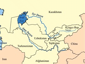
In order to make short work of a long road, we can break down parts of the route for ease of study.   Since the primary interest is the Holy Land, the Levant, we can backtrack from west to east.  There are three major ways from the west to what is called Transoxiana which is the area between the Aral Sea and what is now Uzbekistan, southern Kazakhstan and reaching into Kyrgyzstan and Tajikistan..  
This was the far north east corner of Alexander the Great’s conquests and of the Hellenist culture.  It lacks defensible borders and the soil is fertile but dry.  During the preceding centuries the area became the prize of conquerors from east or west.   


The area came under Chinese influence by the Tang dynasty (618-907) and lost to the Arabs in 715 AD.   In 763 a Tang General defending the western ends of the Silk Road revolted in the An Lushan Rebellion.  The resulting carnage of decades reduced the population, some say, to less than half the original. 

While technically under the Abbasid Caliphate, the area was under the Ghaznavid Dynasty (875-1187) out of Ghazni in present day Afghanistan.  Ethnically the  Ghaznis were another one of Seljuq Turk slave armies that set up on their own. 

As you can see, Transoxiana is a fertile flat area for which access is controlled by a limited number of passes or gates in the Pamir Knot. Hundu Kish area and from Baghdad through present day Teheran. 

The Ghaznavids are credited with spreading Islam into the Indian subcontinent use routes at the time of this writing to use the corridor of the Indus River to the Khyber Pass to Afghanistan to supply US and NATO forces currently operating in Afghanistan.  The major cities included Bokhara and Samarkand to handle trade going north of the Caspian Sea or to go by way of Teheran or through Alexander’s Barrier.
The Ghaznavids  in turn were conquered by Seljuq Turks from their realm in eastern Turkey and Iraq and developed a short lived Kwarezmian Empire founded also by Turkish slave generals.  As you can see the basic shape of Alexander’s conquests continue to reappear, as the major terrain features either facilitate or hinder movement by goods, services and firepower. 

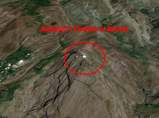
You notice that the great deserts of Iran and western Pakistan make up big chunks of deserted lands with not much to fight over.   Genghis Khan took great pains to wipe this empire out in 1220 AD.  The fleeing Kwarezmians hired out as mercenaries moving west and out of the Mongols way. They were hired by the Ayyubid Dynasty, the descendants of Saladin, to retake Jerusalem from the Christians in 1244. 

Jerusalem had been recovered by treaty between Frederick II, Holy Roman Emperor and the Ayyubids, but there were not enough Christians to make the defense of the city viable.  The Kwarezmian mercenaries destroyed Jerusalem, burning it to the ground and enslaving all they had not killed, including dogs, chickens, cats and livestock.  Then the Ayyubids wiped out the remaining Kwarezmians.  Duplicity is not exactly cruel or unusual.

The Pamir Knot


While all roads lead to Rome in the Roman Empire, all roads going from China to markets in the West or to India, have to contend with the knot of mountains that tie together the ridges that make up the Himalayas.  These include the Tien Shan, the Pamir mountains, the Karakorum mountains, Kunlun and  the Hindu Kush. 

Given the handy model, there are five types of terrain: hill top, hole, fingers, valleys, and the pass.  There are two major means of crossing terrain, cross corridor or with the corridor.  Cross corridor means either running the hill tops (Korea) or across the fingers (most everywhere else. Running with the corridors include high ground atop the fingers, in low ground between the fingers, and through the passes formed by one’s knuckles.

There are three types of slopes that combine to make terrain analysis a study of wiggly brown lines on a topographic map.  There is flat (uniform grade), concave (lines bunch towards the top of a hill, and convex where the lines bunch up at the bottom.

Generally, convex slopes are characteristic of new mountains, the jagged menacing type.  Eventually the rocky jagged convex slope gets worn down until it winds up as another sedimentary level.

Fires, however, come in two varieties with respect to the slopes: plunging or grazing.  All fires eventually plunge, and some plunging fires are crazing across a convex slope.  The tradeoff between slopes and fires is that grazing fire cuts down upright people and forcing them to become a part of the earth voluntarily. Once on the ground, plunging fires which have a small beaten zone, find their targets in low spots on the ground.


 Taking the high ground is nearly always the best course of action, depending on which high ground is take.  A position at the top of a concave slope may be too far to hit targets below, but it is hell to pay if one has to fight up the slope.  The convex slope creates a choice of being too close to the bottom versus not seeing the bottom from the top.

Water is the ultimate chisel on land forms, and the courses they take is as valuable to the soldier.  Using the handy model (in blue) the fifth type of land is the first type of water, that of a puddle or pool, there are no hilltops of the water (waves don’t count).            

Moving across the water courses that follow and make land formations includes: up river, down river, across the fingers (upstream) or across the mouth (downstream),   Alexander the Great used his usual side step – side step at the Battle of the Hydaspes in 326 BC.  That’s after he passed through the Khyber Pass.


Khyber Pass


Alexander’s route of march through what is today a very familiar area to today’s warriors, politicians, and contractors.  The Kandahar-Kabul route he took is a major line of communications to ISAF forces. From Kabul, one can go in multiple directions, and conversely if you want to go to Kabul from India, one goes through the Khyber Pass or to the south through the Dolan Pass.

Alexander crossed through the Dolan Pass in 329 BC and returned through the Khyber Pass in 326 BC.

Since water courses dig the valleys, they run parallel to the ridges that were defined by the erosion in the first place, Young mountains such as are found here, are jagged. 

Alexander followed the Indus south to the present coasts of Pakistan, Baluchistan, and Iran using naval forces in the Indian Ocean and Persian Gulf.  If Alexander’s troops had not asked for a time out, Alexander would have made contact with the Chinese by going through any of a number of passes through these giant mountains. 

Wakhan Corridor


This is a corridor that starts (or ends) in Kabul and follows the Panj River towards China. There is practically no usable roads there, but this route is now the place where China and Afghanistan meet, at the end of a long finger on the political map of Afghanistan. 

Maps of the growth of China along the Silk Road show the history of using this corridor and Fergana Valley in Kyrgyzstan, and Tajikistan.   The Tang Dynasty had extended it’s power well into the other side of the Pamir Knot. 

The expanding Abbasid Caliphate that had conquered the Sassanid Empire base mostly in Iran, ran headlong into the Tang Dynasty in the  Battle of Talas in 751 I which the Chinese lost their hold on the western side of the Pamir Knot.  Not uncommon in tales of this part of the world, the Chinese became outnumbered two to one by the defections of private military companies (mercenaries) and the defection of coalition troops from the Fergana valley.

Shortly afterward, in 755 AD. Chinese general An Lushan of Sogdian ancestry (that area just north of Afghanistan including the Fergana Valley), revolted against the Tang Dynasty and fought a series of wars resulting in a dramatic loss of Han Chinese presence in the Far West. 

Afterwards, these losses made it harder for the Chinese to resist encroachments on or from the Silk Road.  The Chinese seizure of Tibet in 1951 and the colonization of Tibet with the Han, is a classic example of people who know their geopolitical priorities. 


Fergana Valley


To the north of Afghanistan lies the Fergana valley, one noted for good agriculture land and its use.  During the period of the Crusades, it was one of the more traveled routes of the Silk Road.  The Chinese destination to the East is Kashgar where both routes come together.


The Takla Makan Desert

The next stage of the main Silk Road is anchored on Kashgar and travels either north or south of the desert, along a string of oases close to the edge of the desert.  Other branches of the Silk Road avoid the rough terrain for a wide sweep across the Russian Steppes before dropping down to the Silk Road.


One of the more famous routes from the steppes is through the Tsungarian Gate. This picture is directed to the southeast by east as indicated in the small insert.


Some extraordinary work at this site.


Once one moves out of the Takla Makan desert, also referred to as the Tarim basin, one enters the Gansu Corridor that brings the route into the heartland of China.    The Ordos Loop is an upside down U of the upper reaches of the Yellow River.  Why it is called the Yellow river is said to be due to the high wings howling down from Mongolia carrying tons of Loess, a super fine grade of dust.


The Gansu corridor was given up by the Chinese  as a result of the An Lushan rebellion which left the Silk Road under the control of competing Turco-Mongol tribes.

The Ordos Loop


The Yellow river system and its tributaries such as the Wei, was the birthplace of China.  The weather of the Ordos desert and to the south was unpredictable and variable.  The Lower Reaches of the Yellow River whiplashed north and south of the Shantung Peninsula killing millions each time it flooded.


In order to make maximum effective use of widely fluctuating weather conditions which resulted in loss of life and property, the Chinese developed large public works for flood control and irrigation.  As elsewhere in the world, this created the need for a central authority to allocate resources (capital, people, equipment) resulting in strong regional governance. 

In addition to great irrigation works, early Chinese emperors started building giant canals five hundred years BC, which continues today. 


The river systems that define Chinese topography include the Yellow, the Yangtze, and Pearl River.  Shanghai rests on the Yangtze, and Canton on the Pearl. 

The Yangtze creates an east-west line of demarcation between North China and South China.  Over the centuries, the regimes in the North have, from time to time, been unable to conquer the South.
In addition to the extremes of weather, China was faced with huge invasions of horse mounted light cavalry.  From time to time, a Chinese emperor would hire out private military units (mercenaries) to put down revolts, or to fight other horse mounted raiders form the North.

Thus the Great Walls of China were built to extend the effect of the Himalayas that restrict the avenues of approach to China to the Takla Makan Desert and Gansu Corridor.  Based on the fortunes of the times, there are many different walls of China, but generally east west taking advantage of high ground to observe and control traffic below or through.

By the time that the Crusades were starting, China was divided into three parts, and the Silk Road was under control of other nomadic tribes, other than the Mongols.  That changes radically after 1200 with the explosive rise of the Mongols. 

The story of Genghis Khan’s  problems was to get rid of the threat of the XiXia Kingdom before taking on his arch foe, the Jin or Jurchen Dynasty.  The Jurchins were booted out of China by Genghis Khan but it should be noted that they would return as the Manchu or Qing Dynasty that ruled China from 1644 to 1912 (not counting the short lived Manchukuo dynasty under Japanese control in WW2.

This trip from the Levant to China is relevant as within the Thirteenth Century the Mongols would sweep from attacking Japan and Vietnam to Baghdad to the Levant and to seize and burn Kiev in the Ukraine.


Or, put it in an orbital viewpoint:

 Oh yes, Templar Knights faced off with the Mongols at the Battle of Leignitz (Legnica, Poland) on April 9, 1241.  It didn’t work out well.

nnDnn