Of the great issues of the Crusades, the Ground upon which the Crusades were fought on, for, from and to is fundamental of understanding the Crusades and of the Templar Knights who were a central figure in the great drama that was the Crusades.
It is common these days to think of the Holy Land as exclusively related to present day Israel and Jerusalem in particular. Likewise it is common to believe that the Crusades were primarily concerned with the safety of the Holy churches, and towns recounted in the Bible. The objectives of Crusaders are typically portrayed in terms of a great conflict between Islam and Christianity, between Europeans and Arabs.
Actually it’s a lot more complicated than that, even from the broad band approach. For starters, let us look at the continental scope of geographic interest as accounted for by two of the most famous tourists of all time: Marco Polo, who (allegedly) traveled the known world in 1271-1291 from the Venetian Republic to the Court of Kublai Khan and back.
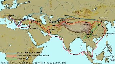

These travels were along long established trade routes collectively called the Silk Road and the trade by sea for spices of the Southeast Asia in addition to the silk from China.


Of particular interest to students of the Crusades is the Great Rift that occurs between the Arabian and African plates as they pull apart. This creates a huge ditch that extends from Lake Nyasa in southern Africa to the Turkish border. It includes famous lakes from the Sea of Galilee, the Dead Sea, the Red Sea, Lake Victoria, Lake Tanganyika and Lake Nyasa.
Of particular importance to students of the Order, is the fact that the northern end of the Great Rift meets at a right angle to the east west ranges of mountains of Turkey, Iraq, and Iran. This is also the junction of the head waters of the Tigris and Euphrates which parallel thus mountainous region. It is this juncture that creates the Fertile Crescent formed between the Rift and the Tigris/Euphrates.


While the vast expanse of the wrinkle that crosses the entire Eurasian landmass is impressive, there is a fairly short list of passes, gaps, and valleys that define the flow of commerce and armies. Traffic favors movement parallel to the wrinkles or fingers, depending on the smoothness or either high or low ground and the access to water.
Water serves as either a barrier or highway, depending on boats and bridges. Once the land is formed by being pushed up by movement of tectonic plates, which provide the basic angle of drainage of water, the water carves out and wears down the initial rock formation. The patterns of drainage, called dendritic patterns, are a quick way to determine the relative relief of the ground often without the ground itself being pictured.

No comments:
Post a Comment